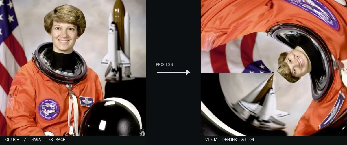
Polar coordinates / rectangular to polar. 2000s: established filter; later Tiny Planet look
Typeface · Comfortaa
Polar coordinate distortion: modern digital demonstration.Digital effect demonstration.View source ↗
Prompt
Apply a polar coordinates effect to the surrounding scenery, wrapping background textures into circular bands and bending straight lines into concentric arcs around a compact planet-like center. Blend the angular seam smoothly and concentrate radial stretching away from defining subject features. Keep the original subject and composition.
Convert apanorama; compare suitable and unsuitable image edges.
Background
Polar coordinates describe points by their angle and distance to acenter. An image transformation can therefore wrap the horizontal extent of arectangle around afull circle and read the vertical direction as the radius. The filter is included in GIMP's documentation from the 2000s; the decade refers to its established availability in image editing software. ATiny Planet is awell-known creative application, but not the entire technique. Text, stripes, and abstract textures can also be transformed in this way. The top or bottom edge of the image is tightly compressed. In the exercise, first check the left and right edges. If they don't match, the circle will be closed with avisible seam.
Distinction
Avisible seam often occurs because the beginning and end of the panorama do not match up.
Further examples · 12 images
02Stereographic projection of a panorama built from 6 pictures. Shot handheld using the tripod as a pole. Part of my (a href="http-www.flickr.This image shows a stadium interior wrapped into a circular shape. The horizontal edges of the original panorama have been joined, creating the characteristic 'tiny planet' appearance common in digital polar coordinate filters.Alexandre Duret-Lutz from Paris, France · CC BY-SA 2.0 · Wikimedia Commons03Planet BielefeldA cityscape is mapped to a circular frame with the ground compressed at the center and the sky at the perimeter. This demonstrates how a rectangular panorama is remapped using angle and radius.TUBS · CC BY-SA 3.0 · Wikimedia Commons04Globe panoramaThe cobblestone ground forms a central sphere while the buildings and trees radiate outward. Visible seams where the left and right edges of the source image meet illustrate the circular wrapping process.Alexandre Duret-Lutz · CC BY-SA 2.0 · Wikimedia Commons05Video Planet Ferry Building in San Francisco AKA Stereographic Video - First TryA urban environment is transformed into a small globe. The architecture follows a circular path, showing the result of converting Cartesian x and y coordinates into polar angle and distance from the center.nate · CC BY-SA 2.0 · Wikimedia Commons06Planet La Silla and the Milky Way (potw2131a)A panoramic landscape of the La Silla observatory is wrapped into a sphere. This 'tiny planet' shows the ground as the central radius and the sky as the outer circumference through polar coordinate mapping.ESO/P. Horálek · CC BY 4.0 · Wikimedia Commons07Polar coordinates filter example - Pixlr Photo EditorA park scene is mapped from rectangular to polar coordinates. The vertical axis becomes the radius, and the top edge is compressed into the center, demonstrating the distortion typical of this mathematical transformation.Stockywood · CC BY-SA 4.0 · Wikimedia Commons08Polar Coordinates — machine versionReal-world algorithm demonstration, applied to a NASA portrait.Atlas of Visual Effects09Dent de Vaulion - 360 degree panoramaA 360-degree landscape is mapped into a circle, creating a tiny planet appearance. It demonstrates the conversion of rectangular panorama pixels into angular and radial coordinates.Alexandre Duret-Lutz from Paris, France · CC BY-SA 2.0 · Wikimedia Commons10Stereographic projection of ParisThis urban panorama uses stereographic projection to wrap a city street into a sphere. The radial distortion demonstrates how Cartesian image data is reinterpreted in a polar grid.Alexandre Duret-Lutz from Paris, France · CC BY-SA 2.0 · Wikimedia Commons11Globe panorama03A coastal landscape warped into a sphere. The sky and clouds are stretched to the outer edges, illustrating the relationship between radius and vertical pixel position.Alexandre Duret-Lutz from Paris, France · CC BY-SA 2.0 · Wikimedia Commons12TinyPlanet mini parkA park scene processed with the 'tiny planet' technique. It provides a clear view of how a linear horizon is mapped to the circumference of a circle.Tunisie Guide 360 · CC BY-SA 4.0 · Wikimedia Commons
Question
Why is an image edge in the center of a Tiny Planet image heavily compressed?
Show possible answer +Hide answer −
Many pixels that were originally next to each other must be distributed around avery small radius or the center point.