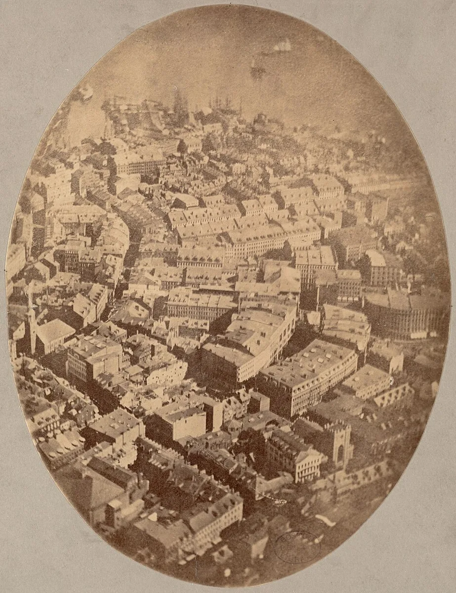
Oval Aerial View of a Waterfront City. An oval sepia photograph shows dense city rooftops, winding streets, and a waterfront from above.Black, James Wallace, 1825-1896 · Public domain · via Wikimedia CommonsView source ↗
Prompt
Apply an early Aerial Photography aesthetic, emphasizing any existing overhead geometry, flattened spatial layers, distant atmospheric haze, and finely resolved surface patterns. Use muted gray-brown plate tones, restrained contrast, slight peripheral softness, and sparse wet-plate blemishes without inventing buildings or changing the viewpoint. Keep the original subject and composition.
An [elevated viewpoint]reveals rooftops, street patterns, and land divisions that are hard to see from the ground. Oblique views1show building sides, while downward views flatten the scene into [map-like shapes].
Principle
Acamera above the ground records reflected light through alens; height and viewing angle determine the visible layout. Early [wet collodion plates2]required exposure3and chemical development while their coating remained wet.
Example
James Wallace Black: Boston, as the Eagle and the Wild Goose See It, 1860.
Try it out
Photograph amodel street from its side, then from directly above; compare visible roofs, hidden walls, and street shapes.
Background
In 1858, Nadar made balloon photographs near Paris, establishing an early milestone in aerial photography. Those photographs do not survive. In 1860, James Wallace Black photographed Boston from aballoon; his famous view is the earliest surviving aerial photograph. These experiments used wet collodion plates, which demanded preparation, exposure, and development before the coating dried. Carrying photographic equipment into aballoon made that sequence difficult. The aerial viewpoint revealed urban patterns rather than merely enlarging familiar street views. Later photographers used kites, aircraft, and other elevated platforms.
Distinction
Unlike adrawn bird’s-eye view, an aerial photograph records light from an actual scene through acamera. It is not automatically amap: tilted views and terrain height can distort scale.
Aftermath
Aerial photography teaches how changing the camera’s position can reveal spatial relationships hidden at ground level.
Further examples · 11 images
02Aerial Panorama of City and HarborA wide monochrome panorama shows waterfront piers and ships beneath a city grid stretching toward the horizon. The high oblique viewpoint gathers the harbor and extensive street network into a single aerial photograph.George R. Lawrence (1869-1938), George R. Lawrence Co. · Public domain · Wikimedia Commons03City Rooftops and Harbor From AboveAn oval photographic print presents closely packed buildings descending toward a harbor dotted with vessels. The view from above exposes roof shapes and street connections while retaining the depth of building facades.Black, James Wallace, 1825-1896 · Public domain · Wikimedia Commons04Dense City Beneath an Oblique Aerial ViewA monochrome photograph surveys a dense city, with large monumental buildings and bare hills in the distance. The aerial perspective reveals the relationship between narrow streets, crowded rooftops, and the surrounding terrain.Eduard Spelterini · Public domain · Wikimedia Commons05Open Field and Neighborhood From AboveA large open field occupies the center of a downward photograph, bordered by trees, roads, and tightly grouped buildings. The steep aerial angle makes land divisions and surrounding roof plans legible as near-maplike shapes.Eduard Spelterini · Public domain · Wikimedia Commons06Rectangular City Blocks From the AirStraight streets divide a city into rectangular blocks, with open grounds and railway tracks near the upper edge. This aerial photograph clearly exposes the street grid and distribution of buildings across an extensive urban area.Eduard Spelterini · Public domain · Wikimedia Commons07Balloon View of BostonA mounted sepia photograph shows Boston rooftops, church spires, curving streets, and waterfront wharves from above. The balloon viewpoint reveals the city's layout while showing building sides through an oblique aerial angle.James Wallace Black · Public domain · Wikimedia Commons08Town Grid and Surrounding CountrysideStraight streets and dense urban blocks extend toward open countryside in this elevated photograph. The oblique aerial view connects individual buildings with the larger patterns of settlement and farmland.Eduard Spelterini · Public domain · Wikimedia Commons09River Town and Bridges from AboveA broad river curves through a densely built town, crossed by bridges and bordered by streets. The aerial perspective reveals the relationship between the river, crossing points, and surrounding urban fabric.Eduard Spelterini · Public domain · Wikimedia Commons10Industrial Works and Spoil HeapsFactory buildings, smoking chimneys, storage yards, and pale spoil heaps spread across an industrial landscape. The aerial viewpoint makes the site's road network and spatial organization visible together.Eduard Spelterini · Public domain · Wikimedia Commons11Urban Streets and Railway from AboveParallel streets flank a long tree-lined space, while a railway corridor crosses the upper portion of the photograph. The downward oblique view organizes buildings and transport routes into a readily legible urban pattern.Eduard Spelterini · Public domain · Wikimedia Commons
Question
Why does a downward aerial photograph look more like a map than an oblique one?
Show possible answer +Hide answer −
Looking downward emphasizes roofs and ground patterns while hiding most vertical walls. An oblique view includes building sides and stronger near-to-far changes in apparent size.